![](/images/other/stat-length.png)
![Tocht Te voet La Mézière - Circuit de La Rivière - Photo](https://media.geolcdn.com/t/1900/400/effb608e-9523-4c80-8eff-d9597a799e45.jpeg&format=pjpeg&maxdim=2)
Circuit de La Rivière
SityTrail - itinéraires balisés pédestres
Tous les sentiers balisés d’Europe GUIDE+
![Lengte](/images/other/stat-length.png)
Lengte
9,1 km
![Max. hoogte](https://static1.geolcdn.com/siteimages/upload/files/1508320355ic_sort_altitude_max_24dp.png)
Max. hoogte
105 m
![Positief hoogteverschil](https://static1.geolcdn.com/siteimages/upload/files/1508320355ic_sort_den_pos_24dp.png)
Positief hoogteverschil
111 m
![Km-Effort](/images/other/stat-length.png)
Km-Effort
10,6 km
![Min. hoogte](https://static1.geolcdn.com/siteimages/upload/files/1508320355ic_sort_altitude_min_24dp.png)
Min. hoogte
55 m
![Negatief hoogteverschil](https://static1.geolcdn.com/siteimages/upload/files/1508320355ic_sort_den_neg_24dp.png)
Negatief hoogteverschil
111 m
![Boucle](https://static1.geolcdn.com/siteimages/upload/files/16400158638029165_repeat_loop_refresh_sync_direction_icon.png)
Boucle
Ja
Markering
Datum van aanmaak :
2022-02-15 18:07:38.023
Laatste wijziging :
2022-03-02 20:25:30.238
![Te voet](https://static1.geolcdn.com/sitytour/trail-icons/100.png)
2h24
Moeilijkheid : Gemakkelijk
![Scan deze QR-code om de tocht te openen in de SityTrail-applicatie](https://capi.geolives.com/qq0zvz2zws4bq2lad0pu/sitytour/trails/3123323/qr.png?size=200)
Gratisgps-wandelapplicatie
Over ons
Tocht Te voet van 9,1 km beschikbaar op Bretagne, Ille-et-Vilaine, La Mézière. Deze tocht wordt voorgesteld door SityTrail - itinéraires balisés pédestres.
Beschrijving
Trail created by Val d'Ille Aubigné Communauté.
Plaatsbepaling
Land:
France
Regio :
Bretagne
Departement/Provincie :
Ille-et-Vilaine
Gemeente :
La Mézière
Locatie:
Unknown
Vertrek:(Dec)
Vertrek:(UTM)
592531 ; 5341437 (30U) N.
Opmerkingen
Wandeltochten in de omgeving
![Tocht Te voet Melesse - Sentier des Melessiens - Photo](https://media.geolcdn.com/t/375/260/0f30e474-f118-48a0-a59b-66ca1ed3bb91.jpeg&format=jpg&maxdim=2)
![Te voet Te voet](https://static1.geolcdn.com/sitytour/trail-icons/100.png)
Sentier des Melessiens
Te voet
Gemakkelijk
Melesse,
Bretagne,
Ille-et-Vilaine,
France
![](/images/other/stat-length.png)
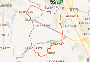
8,5 km | 9,6 km-effort
2h 10min
![](https://static1.geolcdn.com/siteimages/upload/files/16400158638029165_repeat_loop_refresh_sync_direction_icon.png)
Ja
![Tocht Te voet Montreuil-le-Gast - La Fosse du Loup - Photo](https://media.geolcdn.com/t/375/260/23710b22-992a-44ea-99ef-dabc47ec71b0.jpeg&format=jpg&maxdim=2)
![Te voet Te voet](https://static1.geolcdn.com/sitytour/trail-icons/100.png)
La Fosse du Loup
Te voet
Medium
Montreuil-le-Gast,
Bretagne,
Ille-et-Vilaine,
France
![](/images/other/stat-length.png)
18,3 km | 21 km-effort
4h 51min
![](https://static1.geolcdn.com/siteimages/upload/files/16400158638029165_repeat_loop_refresh_sync_direction_icon.png)
Ja
![Tocht Te voet La Chapelle-des-Fougeretz - Les 5 Rottes - Photo](https://media.geolcdn.com/t/375/260/58bed8b2-b520-4e15-968b-0f9cacb497d3.jpeg&format=jpg&maxdim=2)
![Te voet Te voet](https://static1.geolcdn.com/sitytour/trail-icons/100.png)
Les 5 Rottes
Te voet
Gemakkelijk
La Chapelle-des-Fougeretz,
Bretagne,
Ille-et-Vilaine,
France
![](/images/other/stat-length.png)
9,3 km | 10,4 km-effort
2h 22min
![](https://static1.geolcdn.com/siteimages/upload/files/16400158638029165_repeat_loop_refresh_sync_direction_icon.png)
Ja
![Tocht Te voet Gévezé - Circuit du Cheval Blanc - Photo](https://media.geolcdn.com/t/375/260/6a65d215-7eed-44b7-9d26-d5e20ab6f1d2.jpeg&format=jpg&maxdim=2)
![Te voet Te voet](https://static1.geolcdn.com/sitytour/trail-icons/100.png)
Circuit du Cheval Blanc
Te voet
Gemakkelijk
Gévezé,
Bretagne,
Ille-et-Vilaine,
France
![](/images/other/stat-length.png)
3,6 km | 4,1 km-effort
55min
![](https://static1.geolcdn.com/siteimages/upload/files/16400158638029165_repeat_loop_refresh_sync_direction_icon.png)
Ja
![Tocht Te voet Gévezé - Sentier de la Chaussée - Photo](https://media.geolcdn.com/t/375/260/b68bfa03-18ec-4b2e-a7fc-64dc0a472980.jpeg&format=jpg&maxdim=2)
![Te voet Te voet](https://static1.geolcdn.com/sitytour/trail-icons/100.png)
Sentier de la Chaussée
Te voet
Gemakkelijk
Gévezé,
Bretagne,
Ille-et-Vilaine,
France
![](/images/other/stat-length.png)
14,6 km | 16,1 km-effort
3h 39min
![](https://static1.geolcdn.com/siteimages/upload/files/16400158638029165_repeat_loop_refresh_sync_direction_icon.png)
Ja
![Tocht Te voet La Mézière - Sentier de Montgerval - Photo](https://media.geolcdn.com/t/375/260/f85f597a-f5d9-4626-9ff3-a4f1fc6b4cfc.jpeg&format=jpg&maxdim=2)
![Te voet Te voet](https://static1.geolcdn.com/sitytour/trail-icons/100.png)
Sentier de Montgerval
Te voet
Gemakkelijk
La Mézière,
Bretagne,
Ille-et-Vilaine,
France
![](/images/other/stat-length.png)
11 km | 12,3 km-effort
2h 47min
![](https://static1.geolcdn.com/siteimages/upload/files/16400158638029165_repeat_loop_refresh_sync_direction_icon.png)
Ja
![Tocht Te voet Gévezé - Circuit du Moulin de la Moltais - Photo](https://media.geolcdn.com/t/375/260/0b61b143-c705-414e-8194-5fcc4095b5f1.jpeg&format=jpg&maxdim=2)
![Te voet Te voet](https://static1.geolcdn.com/sitytour/trail-icons/100.png)
Circuit du Moulin de la Moltais
Te voet
Gemakkelijk
Gévezé,
Bretagne,
Ille-et-Vilaine,
France
![](/images/other/stat-length.png)
7,8 km | 9,1 km-effort
2h 3min
![](https://static1.geolcdn.com/siteimages/upload/files/16400158638029165_repeat_loop_refresh_sync_direction_icon.png)
Ja
![Tocht Te voet Gévezé - Circuit de la Motte Marcillé - Photo](https://media.geolcdn.com/t/375/260/92a5fd14-c2a6-4b26-bc47-2f8fa78eecb4.jpeg&format=jpg&maxdim=2)
![Te voet Te voet](https://static1.geolcdn.com/sitytour/trail-icons/100.png)
Circuit de la Motte Marcillé
Te voet
Gemakkelijk
Gévezé,
Bretagne,
Ille-et-Vilaine,
France
![](/images/other/stat-length.png)
6 km | 7,1 km-effort
1h 36min
![](https://static1.geolcdn.com/siteimages/upload/files/16400158638029165_repeat_loop_refresh_sync_direction_icon.png)
Neen
![Tocht Paard Vignoc - Sentier de Gripail - Vignoc - Photo](https://media.geolcdn.com/t/375/260/ext.jpg?maxdim=2&url=https%3A%2F%2Fservices.sitytrail.com%2FGeolivesWS%2FDownloadMedia.ashx%3FTrailID%3D112614%26Media%3D11178_4.jpg)
![Paard Paard](https://static1.geolcdn.com/sitytour/trail-icons/300.png)
Sentier de Gripail - Vignoc
Paard
Medium
Vignoc,
Bretagne,
Ille-et-Vilaine,
France
![](/images/other/stat-length.png)
12,8 km | 14,2 km-effort
2h 0min
![](https://static1.geolcdn.com/siteimages/upload/files/16400158638029165_repeat_loop_refresh_sync_direction_icon.png)
Ja